| The Magazine of the CALIFORNIA ACADEMY OF SCIENCES |
|
|
|
|
|
A CLOSER LOOK Where the Faultline Meets the Coastline
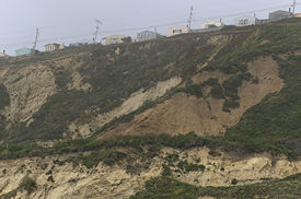
Photographs by Dong Lin Mussel Rock Beach marks the spot where the San Andreas Fault crosses the shoreline after a long journey through inland California. One of the most unstable sections of North Americas Pacific rim, the Mussel Rock area highlights what can happen when man attempts to expand his habitat from sea to shining sea. Together the beach and adjacent seacliff offer a revealing glimpse into the coastlines prehistoric past, and a preview of its dynamic future.
The path to the beach lies along the large, flat bench of the Mussel Rock landslide. Above it, homes from Daly Citys Westlake development are perched precariously on the naked edge of the eroded cliff. Gaps in the row of houses reveal where 15 homes have already been removed, victims of the relentless movement. Deep underfoot, bisecting the enormous slump, lies rock crushed by the earthquake fault that destroyed San Francisco in 1906. The San Andreas fault helps define the boundary between two large pieces of the Earths floating crust. The many efforts to stop the landslides progress range from a network of pipes that dump runoff directly into the sea, to rock walls held together with chicken-wire, to plantings and haybales meant to hold the slumping earth in place. Finally, a large rock seawall shores up the toe of the landslide at the oceans edge. To date, all have failed or are failing, as this 5,000-year-old landslide marches remorselessly to the sea. Scanning the cliff as it extends north toward San Francisco, one can see the brushy green remnants of a terrace cut halfway up the cliff. This is all that remains of a roadbed first built for the Ocean Shore Railway in 1905, and later, after its failure, reworked as Highway 1. Only after the 1957 earthquake, the strongest in the region since 1906 and centered in Daly City, was the whole idea of a transport route along the shore abandoned. From the landslide bench, Mussel Rock itself is visible just offshore. It is the largest of several rocks that have become separated from their parent sea cliff. This blackish-green assemblage contrasts sharply with the paler, layered sedimentary rocks in the cliffs to the north. Older than the sedimentary formation, the greenstone assemblage is part of the Franciscan Complex, which is the bedrock under San Francisco. Sea floor basalts carried east from the Pacific Ocean were subducted under the westward moving North American plate, and about 80 to 90 million years ago Mussel Rock was left smeared onto what is now the Pacific Coast. The neighboring sedimentary rocks, known as the Merced Formation, began accumulating about 3 million years ago. There is an 80-million-year gap in time between these adjacent formations, as if a handful of pages had been torn out of a book. The missing layers may have been swept away as fast as they formed, or they may have been eroded subsequently. Right opposite Mussel Rock is a low cliff promontory pierced by a tunnel about ten feet wide, ten feet high and 90 feet long. Known as Tobins Folly, the tunnel was carved through the solid Franciscan rock for Hibernia Bank cofounder Richard Tobin in 1874. He wanted to be able to ride his buggy back and forth between his familys city home and their house in Rockaway Beach, Pacifica, south of Daly City. The tunnel was a disaster from the beginning. First, Pacific storms rearranged the surrounding sand, both redepositing sand in the tunnel cavity and eroding sand from the approach to the tunnel. Nature delivered the coup de grace in 1906, when the earthquake reportedly knocked off most of the rock tunnel and threw it into the ocean, leaving the tunnel in its present disabled state. The tall cliffs abutting the tunnel to the north contain spectacular examples of fault gouge. Zones of crumbly rock powder formed as the sides of the fault ground past each other, pulverizing the Franciscan greenstone basalt as millstones grind grain into flour At the end of the crumbling seawall road, a rapidly eroding sea cliff meets the beach. Here, at the northern edge of the Mussel Rock landslide, the sedimentary Merced Formation is exposed. After scrambling down to the beach, a leisurely walk northward to Fort Funston, close to the sea cliff, demonstrates how the coastal environments have changed over the past 3 million years. At first sight, the cliffs are an undecipherable jumble of dirt, mud, trickling watercourses, and sandstone/siltstone outcroppings set in an overall structure of landslide scarps, gouges, and debris deposits. But within this region of constant erosion and instability, recognizable patterns can still be seen. Coherent layers (strata) of rock stand out here and there through the overwashed mud. Often they can be dated by identifying the embedded fossil mollusks, sand dollars, and barnacles. Other strata identify themselves by their pebbles, which poke out like fruits in a muffin. Strata can often be picked out near the beach and followed far up the bluff. All of these layers dip down to the northwest, or, put another way, the rocks have all been tilted upward by the movement of the San Andreas Fault to the south. Like all sedimentary rocks, these were originally laid down in an ancient basin in nearly horizontal layers. Over time, the basin was uplifted and tilted, with the youngest sediments exposed at the Fort Funston edge. Walking north along the beach is, in effect, climbing diagonally along a one-mile deep basin which now lists to one side like the sinking Titanic. Many of these layers were deposited when the rock was under as much as 300 feet of seawater. But careful cliff scanning reveals numerous streaks of buried, fossilized plant material known as lignite. Slanting up the cliff as thin black/brown lines or ribbons, the lignite deposits may widen to a thickness of two to three feet thick. They formed when the bedding surface was an inland freshwater swamp which eventually reverted to seafloor. The most important chronological reference marker for the sea cliff is found just past Thornton Beach, a half-hours walk north of Mussel Rock. A thin white stripe appears well up the cliff, dipping characteristically northwest. This is a layer of volcanic ash from an eruption in the Mount Lassen area more than 250 miles to the north. It has been dated at about 450,000 years old and divides the older layers to the south from the younger ones to the north. A visit to Mussel Rock Beach is a perfect way to explore and understand what is unique and spectacular about the natural setting of San Francisco. Positioned at the boundary of two of the earths largest tectonic plates, it bears witness to the power of coastal erosion while displaying rocks that record three million years of continuous, often violent, change. Dan Sudran is a San Francisco teacher and the director of the Mission Science Workshop at City College of San Francisco.
|